Successful trail navigation is an important part of any outdoor adventure. Whether you’re skiing into a hut for an overnight, biking the trails for the day, or just out for a stroll in the fresh air, make sure you know what trail signs to look for before heading out. Here’s a quick reference:
Maine Hut Trail Corridor
 The Maine Hut Trail is the primary trail corridor that links the huts. An 8 to 10-foot wide trail, it’s kept groomed for Nordic skiing, and is also a great choice for hiking, biking, fat biking, and snowshoeing.
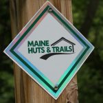
In most places, this trail is similar to classic Maine camp roads. In other places it softens into a mowed grassy trail. This trail is always marked with white reflective diamonds that display the Maine Huts & Trails logo.
Side Trails
 Also called backcountry trails, these are generally narrower than the Maine Hut Trail and many are perfect for hiking and snowshoeing. Some are also appropriate for mountain biking, fat biking, and backcountry Nordic skiing. Since they’re not groomed in the winter, be prepared to break trail if you’re the first one out after a big snowfall.
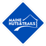
These trails range from rocky and root-covered to sandy and grassy. They’re marked with a blue reflective diamond with the Maine Huts & Trails logo.
Wooden Trail Signs
In addition to white diamonds, blue diamonds, and blue blazes that mark the way, the entire trail system also has wooden signs. These provide more details about your location and where each trail leads. Look to signs like these to tell you when you are on the Maine Hut Trail or an ancillary trail, as well as the distance and direction to the next hut or trailhead.
Other Signs & Trail Markers
Western Maine is home to a variety of recreational trails, and our trail system runs parallel, perpendicular and adjacent to many of them. While we encourage you to enjoy all the trails in the area, it’s important to recognize when you’re no longer on the Maine Huts & Trails system.
These other trails include mountain biking trails, the Appalachian Trail, snowmobile trails, ATV trails, and other multi-use systems like the Narrow Gauge Pathway, that are all maintained by other organizations. Many of the mountain bike trails are maintained by Carrabassett Region New England Mountain Bike Association (CRNEMBA) while the Narrow Gauge Pathway is maintained by the Town of Carrabassett Valley. Snowmobile and ATV trails are usually maintained by local area clubs and volunteers.
It is also important to note that not all trails are multi-use trails, and some trails allow activities that others do not.
So how do you know if you are on a shared section of trail or on another trail altogether? Keep an eye on the signs and look for inconsistencies.
All these trails use their own trail marking systems, so it’s important to pay attention and recognize when signs begin to look different. While we cannot provide a complete reference, here are a few examples to look for:
- The Appalachian Trail is marked by white blazes.
- CRNEMBA mountain bike trails often use white signs with blue, green or black shapes to identify trails.
- Snowmobile trails often reference “ITS” or names like “The Black Fly Loop.”